1786-1800
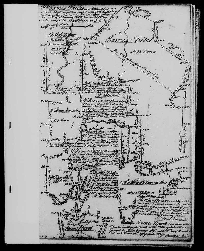
Soon after Thomas Leonard had his survey on Big Generostee on 9 February 1786, his brother William also had a survey of 200 acres just north of his brother Thomas on 21 February.[3] The plats for both brothers’ land are recorded on the same page in the Commissioner of Locations Plat Bk. B for the South Side of the Saluda River in Ninety-Six District. Both Thomas and William Leonard’s surveys were done by John Cowan.
In another posting I’ve made in the past, I noted some valuable historical commentary on why people were claiming land grants in the South Carolina upcountry in this time frame. The posting I’ve just linked cites a 2021 article by Wade Dorsey for the blog of the South Carolina Archives and History which explains,
When the British evacuated South Carolina in 1783, they left an independent but prostrate state. Having suffered through eight years of war and having experienced more battles and skirmishes than any other state, South Carolina was destitute. Aside from her exhausted population, her only real asset was vacant lands that had not yet been granted. In 1784 the General Assembly passed “An Act for Establishing the Mode and Conditions of Surveying and Granting the Vacant Lands Within this State.” It is important to understand that lands granted by the State were not, for the most part, for military service but were essentially purchases of vacant lands by the grantee. Along with cash payment, one could pay these costs with a promissory note called an indent that had been issued to pay for military service or providing supplies. At first the price was $10.00 per hundred acres, with the price dropping in 1791 to the cost of the office fees and surveying. Out of the many thousands of grants, there were several hundred bounty grants given at no cost to veterans of South Carolina’s Continental Regiments.
As David Ramsay notes in his classic study of the settlement of the South Carolina backcountry, having taken the British side during the Revolution, in 1777 the Cherokees ceded to South Carolina all their lands east of the Unacaye mountains, and in 1784, a land office was opened to sell the land at $10 per 100 acres.[4] The low price, fertility of the soil, and healthiness of the climate spurred rapid settlement in the backcountry.
In addition to my Leonard and James ancestral lines, I have multiple other family lines obtaining land in Ninety-Six, soon to be Pendleton, District in these years. These include my ancestor Mary Calhoun Kerr, who had a survey for 350 acres on Twelve Mile River on 16 June 1784. Mary followed her brother John Ewing Colhoun to Pendleton District: he had a survey for 640 acres on Twelve River on 21 May 1784. On the same day, John E. Colhoun’s brother-in-law Andrew Pickens, who married Mary Calhoun’s sister Rebecca, had a survey for 573 acres just south of where John E. Colhoun’s land lay. Mary’s son John Kerr had a survey for 640 acres on 16 July 1784. As John E. Colhoun began setting up his plantation Keowee Heights in Pendleton district, his niece Jane, daughter of Mary Calhoun Kerr, and Jane’s husband John Green also settled in Pendleton District to manage the construction of John E. Colhoun’s Keowee Heights house before having a survey of their own for 838 acres on the Keowee. John Green and Jane Kerr are my direct ancestors. These Abbeville families acquiring land in Ninety-Six/Pendleton District in this time frame were thickly interrelated: Mary Calhoun’s husband Samuel Kerr was a cousin of Andrew Pickens through Samuel’s mother, Margaret Pickens Kerr.
I’ve also noted the arrival of my ancestor John Mauldin in Ninety-Six/Pendleton District by 11 March 1785, when he had a plat for 320 acres on Governor’s Creek. As the linked posting notes, John’s son-in-law John Lauderdale, who married John’s daughter Milbury and who is another direct ancestor of mine, may initially have lived on Mauldin family land in the late 1780s. John Mauldin came to Ninety-Six/Pendleton District from Granville County, North Carolina. Another ancestral line of mine following the same migration path a few years later about which I haven’t yet posted information was the family of Jacob Braselton: Jacob bought 200 acres on the Keowee on 3 September 1792.
Thomas Leonard’s household is enumerated on the 1790 federal census of Pendleton District, with one male over 16, six males under 16, and one female in the household.[5] The composition of the household matches what we know about Thomas’s household in 1790: he and wife Hannah had six sons, Robert (b. 1777), John (b. 1779), Thomas (b. 1781), Hezekiah (b. 1784), Samuel (b. 1786), and Griffith (b. 1787).
Two households away from Thomas Leonard’s household is the family of his brother-in-law Samuel Dean (the surname appears as Deen), and on the subsequent page and living near his brothers-in-law is Harmon Cummings. A 4 May 1826 deed of Samuel Dean to his son Moses Dean will tell us that Samuel Dean and Thomas Leonard had adjoining tracts of land on Mountain Creek: the deed states that the 330 acres Samuel was deeding to son Moses was on the dividing line between Samuel’s land and that of Thomas Leonard.[6]
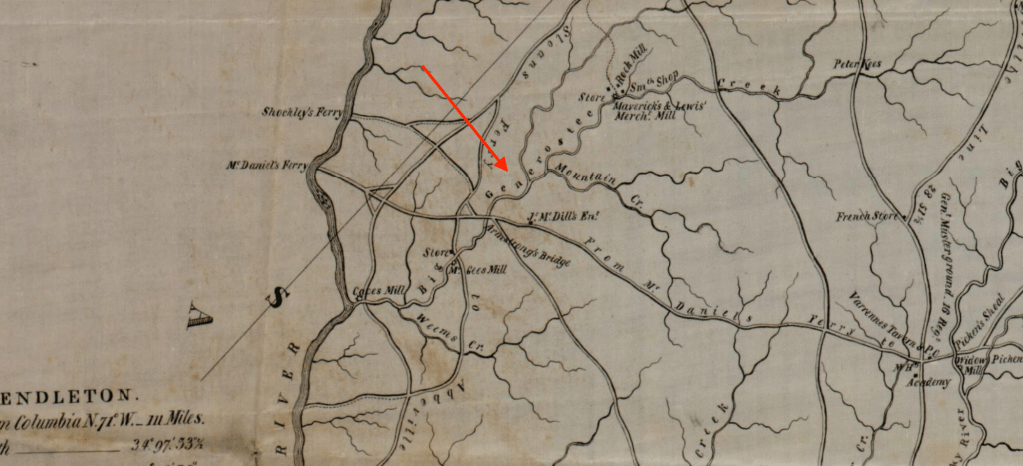
As Robert Mills’ 1825 map of Pendleton District shows, Big Generostee, where Thomas’s 1786 land grant was located, runs from east to west through Pendleton District to the Savannah River, with Mountain Creek running from east to west to meet Big Generostee before the conjoined streams reach the Savannah. A digital image of a portion of the Mills map is at this previous posting about John Lauderdale, whose daughter Sarah married Thomas Leonard’s son Thomas Lewis Leonard; as the linked posting notes, John Lauderdale had a grant on Big Generostee on 1 November 1786, and his land grant was near the junction of Big Generostee and Mountain Creek. The confluence of the Big Generostee and Mountain Creek occurs a few miles west of present-day Starr, South Carolina, and just east of Lake Hartwell, which was formed from the damming of the Savannah.
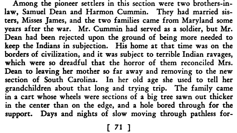
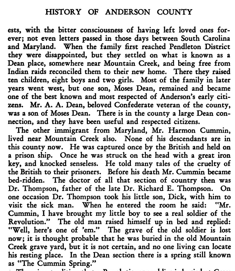
Anderson County, South Carolina, historian Louise Vandiver notes that both Samuel Dean and his brother-in-law Harmon Cummings settled near Mountain Creek in what would eventually become Anderson County.[7] Vandiver recounts stories told by Samuel’s wife Gwendolyn James about the families’ move from Maryland to Pendleton District, stories that Samuel and Gwenny’s descendant Beverly Dean Peoples thinks Dean descendants recounted to Louise Vandiver.[8] As Beverly notes, Samuel Dean became an extensive planter in the southern part of Anderson County, where he and his in-laws Thomas Leonard and Harmon Cummings lived near Mountain Creek Baptist church, in whose old cemetery at Starr Samuel and Gwendolyn James Dean are buried. The cemetery is now known as the Dean family cemetery. A hamlet called Deans, named for this Dean family and marking where Samuel Dean lived, is less than two miles north of Starr on highway 81.[9] Samuel, wife Gwenny, Gwenny’s mother Mary James, and Gwenny’s sister Mary and husband Harmon Cummings appear in the records of the old Mountain Creek Baptist church.
By January 1792, Thomas Leonard was serving on the local court jury: court minutes for 24 January 1792 state that he was drawn as a petit juror for court sessions.[10] Court minutes for 25-27 June show Thomas serving on the petit jury in cases including the trial of John Lauderdale for petty larceny.[11] Lauderdale, whose daughter Sarah married Thomas Leonard’s son Thomas about 1800 in Pendleton District, was found guilty.
On 12 July 1792, when John Landers sold Samuel Dean five acres out of Landers’ 300-acre grant on the Big Generostee, Thomas Leonard witnessed the land sale.[12] Thomas proved the deed on 23 February 1793. On 17 June 1794, Thomas again witnessed a deed made to Samuel Dean, this time by Jacob Herring.[13] Witnessing this deed along with Thomas was his and Samuel’s father-in-law Griffith James, who had followed his children from Washington County, Maryland, with their mother Mary after selling his home tract in Washington County on 13 May 1792.[14]
On 29 August 1795, Thomas and Robert Leonard witnessed the sale by Samuel Bradcutt to Samuel Dean, both of Pendleton District, of 25 acres on Big Generostee bordering land owned by Samuel Dean.[15] Thomas and Robert Leonard both signed, Thomas’s surname recorded as Linard and Robert’s as Lineard, and Thomas proved the deed on 25 October 1797. The Robert Leonard witnessing this deed was either Thomas’s brother Robert or Thomas’s son of the same name, who was eighteen in 1795.
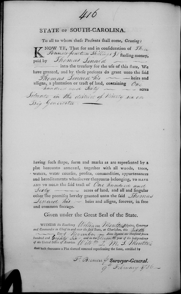
On 10 October 1795, Thomas Leonard (signing as Thomas Leneard) sold his 160-acre grant on Big Generostee to James Long for £20 sterling Deed to James Long.[16] The deed states that the land had been granted to Thomas on 6 November 1786. Samuel Dean and Francis Prine witnessed the deed and Francis Prine Jr. proved it on 31 October 1795, with the deed being recorded 7 May 1796. James Long and wife Margery then resold this land on 23 October 1795 to Henry Houston with the deed noting that of the 200 acres they were selling to Houston, a portion came from land granted to Thomas Leonard, who sold this land to them.[17]
A 26 January 1797 deed to Harmon Cummings shows that he and Thomas Leonard held adjoining pieces of land. Harmon Cummings bought 640 acres on Mountain Creek of the Great Generostee from James Martin of York County, South Carolina.[18] The deed notes that the land was bordered on the west by Thomas Leonard, on the south by Walker, and included land where Harmon was then living.
On 11 April 1798, Thomas Leonard witnessed a deed of James Kilgore of Greenville County, South Carolina, to Moses Hendrix of Pendleton District for 200 acres of land in Pendleton District.[19] Witnessing the deed along with Thomas Leonard was his brother-in-law Colin Campbell, who proved the deed on 29 May 1798. The deed record has Thomas signing his surname as Linard.
1800-1808
The family of Thomas Leonard is enumerated on the 1800 federal census of Pendleton District with a household comprised of two males under 10, five males 10-15, and one male 45+, as well as one female under 10 and one female 45+, with two enslaved persons in the household.[20] The age groupings of Thomas’s seven sons on this census are off somewhat: of the first five, Robert, John, Thomas, Hezekiah, and Samuel, only Samuel was under fifteen years of age. Of the two younger brothers, Griffith James and Colin Campbell Leonard, only Colin was younger than ten. Thomas’s daughter Hannah was five years old.
Note that this census listing allows us to track when Thomas Leonard began investing in the economy of slavery by buying enslaved persons: as noted previously, the 1790 federal census shows him with no enslaved persons in his household. By 1800, he has acquired two enslaved persons. As we’ll see below, in 1802, he sold two enslaved persons, evidently children or adolescents. It’s not clear whether these are the two enslaved persons enumerated in his household in 1800. Down the road, the 1820 federal census will show him holding four people in bondage in Lincoln County, Tennessee, and the 1830 federal census will enumerate eight enslaved persons in his household. His 9 July 1829 will in Lincoln County will bequeath enslaved persons Moses and Hannah, a couple, and Nanny to his wife Hannah, and shortly before his death, he’ll sell enslaved persons Dick and Mack to his son Griffith. The story of Thomas Leonard is the story of the many middle-class farmers of the South who began their adult lives not owning enslaved people, but who began investing in enslaved persons as the cotton economy developed following Eli Whitney’s invention of the cotton gin and as the slave system extended to the old Southwesst.
As discussed previously, on 12 September 1800 in Pendleton District, Thomas, his mother Honor and brother Robert, and brother-in-law Colin Campbell signed a power of attorney to James Irwin of Cumberland County, Pennsylvania, empowering him to retrieve pay due to Robert Leonard elder for military service he gave during the French and Indian and Revolutionary war, and evidently also to secure any grant of land that might be due to Robert.
On 6 March 1801, James Kilgore of Greenville District, South Carolina, sold Thomas Leonard of Pendleton District for $1,000 640 acres of land lying on both sides of Wolenoy (i.e., Oolenoy) Creek.[21] Witnessing the deed, which Kilgore signed, were Colin Campbell and James Coffee. Kiziah Kilgore relinquished dower on 18 March and Colin Campbell proved the deed on 22 February 1802, with the deed being recorded on 6 March 1802. Thomas’s surname is given as Lineard in this deed.
On 2 February 1802, Thomas sold Cornelius Keith for $250 enslaved persons Jainy and Darby, described as mulatto and born of an unnamed enslaved woman, with Colin Campbell and John Keith witnessing.[22] Thomas signed as Thomas Leonard and John Keith proved the deed 22 April 1808. Cornelius Keith was a neighbor of Thomas Leonard: a 1 October 1803 deed of George Carr and wife Judith to Cornelius Keith for 50 acres on Woolanoia Creek (i.e., Oolenoy Creek) notes that the land Carr was selling bordered Keith and Leonard.[23]
On 23 November 1804, Thomas Leonard sold Samuel Copeland, both residing in Pendleton District, for $400 100 acres on Carrs Creek, signing as Thomas Lenard with witnesses John Keith, John Lenard, and Hezekiah Lenard.[24] Keith proved the deed on 2 January 1808 and the deed was recorded on 6 January 1809. John and Hezekiah Leonard were Thomas’s sons of those names.
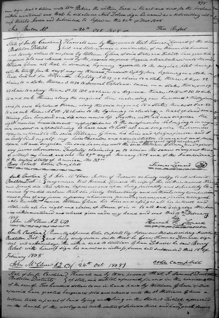
On 29 January 1808, Thomas Leonard sold William Glenn for $1,620 506 acres in Pendleton District, the deed stating that Thomas was living in Pendleton District.[25] The deed references the original plat of the land dated 24 May 1784 and states that the tract bordered Samuel Copeland’s corner. This land was evidently Thomas’s homeplace, since wife Hannah relinquished dower on 15 February 1808. Witnesses to the deed were Berry Roberts and Colin Campbell, with Colin proving the deed 15 February 1808 and the deed being recorded 24 October 1808. I think this land must have been the tract Thomas Leonard bought from James Kilgore on 6 March 1801, and that he had sold 100 acres out of this tract to Samuel Copeland on 23 November 1804.
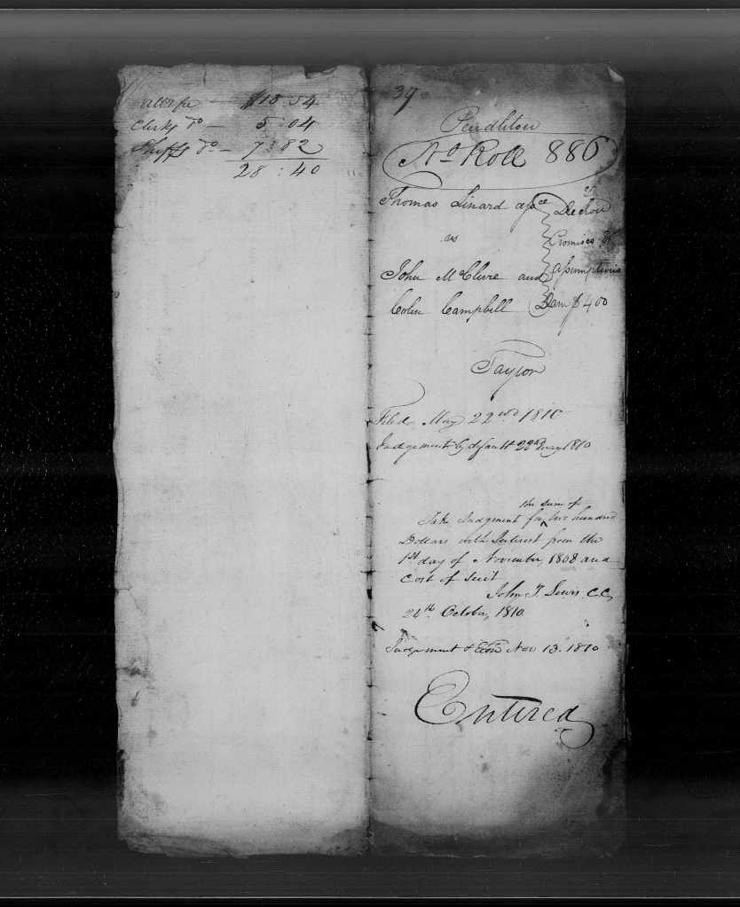

Pendleton District court judgment rolls document a case filed by Thomas Leonard (the surname is written as Linard) on 22 May 1810 (after he had moved to Tennessee) that appears to have been generated by this land sale.[26] The case concerned a promissory note for $200 given by John McClure and Colin Campbell to William Glenn on 6 October 1807. Glenn then assigned the note to Thomas Leonard on 28 November 1809, I suspect in partial payment for the land he had bought from Thomas in January 1808. Court judgment was in favor of Thomas for $400, which included damages.
As a previous posting notes, Thomas Dunlap Leonard’s “Biography of the Leonards” states that Thomas and Hannah James Leonard moved their family from Pendleton District, South Carolina, to Lincoln County, Tennessee, in 1806. Yet the 29 January 1808 deed Thomas made to William Glenn as he and Hannah sold their homeplace in Pendleton District states that Thomas was living there when that deed was made, and the family was still in Pendleton District on 15 February 1808 when Hannah relinquished dower for this land sale. The Leonards moved to Tennessee between the February 1808 date and 21 September 1809, when Thomas bought land in Lincoln County, Tennessee. In my next posting, I’ll take up the story of his final years in Tennessee from that point forward.
[1] South Carolina Plat Books (Charleston Series), vol. 16, p. 35; and Ninety-Six District, South Side of Saluda, Commissioner of Locations Plat Bk. B, p. 113, giving the survey date as 9 February and recording date for the plat as 21 February. The same page has a plat to Thomas Leonard’s brother William dated 22 February. The South Carolina Plat Bk. record spells the surname as Linard, and the Commissioner of Locations Plat Bk. uses the Leonard spelling.
[2] South Carolina Grant Bk. 15, p. 416. When Thomas Leonard sold this 160-acre grant to James Long on 10 October 1785, the deed stated that the land had been granted to Thomas on 6 November 1786 with the grant recorded in Grant Bk. 2222, p. 43: see Anderson County, South Carolina, Deed Bk. C & D, pp. 207-8.
[3] South Carolina Plat Books (Charleston Series), vol. 15, p. 127; and Ninety-Six District, South Side of Saluda, Commissioner of Locations Plat Bk. B, p. 113.
[4] David Ramsay, Ramsay’s History of South Carolina from Its First Settlement in 1670 to the Year 1808, vol. 2 (Newberry, South Carolina: Duffie, 1858), p. 124.
[5] 1790 federal census, Pendleton District, South Carolina, p. 6. The surname is spelled Lennard.
[6] Anderson County, South Carolina, Deed Bk. R, p. 482.
[7] Louise Ayer Vandiver, Traditions and History of Anderson County (Atlanta: Ruralist, 1928), pp. 71-2.
[8] See Beverly Dean Peoples and Ralph Terry Dean, Country Cousins: Descendants of Samuel Dean, 2nd edn. (Franklin, North Carolina: Genealogy Publishing, 2001), p. 5; and Beverly Dean Peoples, “The Dean Family of Dean, South Carolina, Anderson County,” in Anderson County South Carolina Heritage — 2007, Anderson County Chapter of South Carolina Genealogical Society, ed. (Waynesville, North Carolina: Walsworth, 2007), pp. 203-4.
[9] For a map of the portion of southern Anderson County east of Deans, see Robert Z. Callaham, Early Landowners South of Anderson, SC (Walnut Creek, California; 2012), pp. 84-5.
[10] See Pendleton District, South Carolina, Court Minutes Bk. 1790-1793, p. 98, abstracted in “Pendleton County Court Minutes,” South Carolina Magazine of Ancestral Research 6,4 (1978), p. 214.
[11] See Pendleton District, South Carolina, Court Minutes Bk. 1790-1793, pp. 114, 131, 138; and Pendleton County Court Minutes,” South Carolina Magazine of Ancestral Research 7,1 (1979), pp. 37, 38, 41.
[12] Anderson County, South Carolina, Deed Bk. B, pp. 136-7.
[13] Ibid., Bk. C & D, p. 360.
[14] Washington County, Maryland, Deed Bk. G, p. 771-2.
[15] Anderson County, South Carolina, Deed Bk. M, p. 458.
[16] Ibid., Deed Bk. C & D, pp. 207-8.
[17] Ibid., p. 207. Henry Houston and wife Kiza sold the 200 acres on 28 October 1799 to Peter Keys, with the deed stating that the land was in Washington District of Pendleton County: Anderson County, South Carolina, Deed Bk. E, pp. 143-4. On Peter Keys, to whom John and Milbury Mauldin Lauderdale also sold land, see this previous posting.
[18] Anderson County, South Carolina, Deed Bk. B, pp. 311-312
[19] Ibid., p. 450.
[20] 1800 federal census, Pendleton District, South Carolina, p. 110A.
[21] Ibid., Deed Bk. G, pp. 10-11.
[22] Ibid., Bk. I & J, p. 273.
[23] Ibid., Bk. H, p. 32.
[24] Ibid., Bk. I & J, p. 123.
[25] Ibid., p. 278.
[26] Pendleton District, South Carolina, Judgment Rolls no. 886.

3 thoughts on “Thomas Leonard (1752-1832), Son of Robert Leonard and Honor Pritchard: South Carolina Years (1786-1808)”